The ship is single on the map in real time. MarineTraffic (Marine traffic) - AIS real-time ship tracking map in Russian. How Marine traffic works
Thanks to the development of technology, modern society managed to fully develop ship transportation. Once upon a time, people traveled on wooden ships, guided by the stars, losing a huge amount of time on swimming. Then steamboats appeared, slightly accelerating these processes. However, now not only the vessels themselves have improved, but also the operational exchange of information.
Motor ships online in real time: what are the cards and how to use them
Today, an automatic identification system has been created that works thanks to radio waves broadcast using a transmitter and receiver. This is used to ensure that ships can follow a safe route and are always under surveillance. This system can be used not only by the leading persons of the shipping companies, but also by every person who wants to know the location of the required vessel. The use of satellite map technology made it possible to create special real-time sea charts of motor ships that provide all the necessary information about active ports, ships and their course.
Passenger ship
Online maps of ships
So, there are many different services that offer their help in order to find a ship. Typically, these resources are presented in the form of a map, which shows all the existing civil ships and their movement. Each such vehicle has its own unique cipher, which is broadcast and decrypted via satellites. Thanks to this, anyone can find out general information about the ship: location, route, speed, type, cargo, and even a photo.
Important! Technology is not absolute. Information is updated, of course, in real time, but there are many reasons for signal delay, for example, blind spots in certain places on the route. Therefore, the speed values, as well as the location of the ship, are likely to be inaccurate.
However, despite the fact that all sites have a common goal - to show the route of ships on a map in real time, they have different functions. For example, Scanmarine, which is located on the Russian segment, shows the area schematically without the ability to select a satellite or another view, you can also only click on the marker to get acquainted with the information, but you cannot find the vessel by name. To get more options, you need to follow the link that can be seen on the map frame, or simply enter vesselfinder.com in the search engine.
On the Internet, you can find many resources that use the same type of maps, for example, Google or Yandex. By going to the official page, you can use the search and get more accurate information.

Schematic map without relief
Passengers will have enough of these functions, but if other goals or more needs are a priority, then they will have to register, and on some sites, in order to get all the features, they will also have to buy premium access. It should be said right away that one of the most popular now is Marinetraffic.com. This is due to its efficiency, convenience, simplicity and frequency of location updates.
How to use it?
When the site opens, you can immediately pay attention to the map, where there will be a huge number of markers of different colors, shapes and sizes. To deal with this, you need to look into the legend or additional footnotes, since different resources have different markings (in fact, there are about 3 cards themselves different types that everyone uses when posting on their pages). Of course, it will be very difficult to find the necessary vessel in this chaos. Some sites offer a search that will immediately switch to the zone where the required liner is located and its path along the route.

Found ship using search: satellite view
The map allows you to see the entire surface of the globe, which greatly increases the possibility of tracking the ship. Everything is interactive - you need to hold down and move the mouse cursor in the required direction, so you can quickly move between different points of the planet. In addition, among other tools, zooming in, changing the view (standard, simplified, satellite, hybrid), and in some even weather will be available. By the way, on the original sites with maps, when registering, they ask for what purposes the resource will be used. The number of functions that will be available depends on this answer.
So, step by step instructions:
- You need to open the site and get acquainted with the map and the legend.
- Register (required if you intend to use the "search" function).
- Click on the magnifying glass icon in the upper left corner, enter the exact name of the ship and wait for the map to load the area and route.
Note! Small boats are not monitored.
Is it worth contacting public services?
It is not always necessary to contact online maps to track your ship among thousands of others around the world. As an example, consider a river walk in your city. In this case, it is better to request a number from the port office in advance. public service to find out the schedule and negotiate for tickets. It will be more practical than studying vehicle tracking. It is also not recommended to communicate with services using Email as it can take a long time to get a response. It all depends on the case, since the request can be queued or take a long time to process.
The AIS system has become very useful for all citizens different categories. For entrepreneurs or people who have entered into a contract, it is very important to keep track of their cargo, which transports a certain vessel, as well as all other information about it.

Characteristics of the Carnival Fantasy ship
Thanks to radio signals, which are amplified by special positions with antennas, it is possible to calculate the time and correct route very accurately. Of course, for ordinary passengers, such a system is very useful, universal and in some cases the only one. Having studied the methodology of actions a little, you can easily find out all the answers to your questions.
Search and determination of the position of the vessel
based on data from AIS. All positions of ships, departure from the port and arrival at the port of destination in real time.Attention! Vessel positions sometimes they may not correspond to the real ones and lag behind by an hour or more. All vessel position coordinates are provided for informational purposes only. Search data from AIS (AIS) cannot be used for route planning
When searching, you will find accurate information about the movement of ships on the map according to the data AIS and you can see their photos. In order to find a ship, select a sector on the map, where the number of ships currently located there is indicated. We click with the mouse, for example, on the region of Europe and get the picture that you see above.
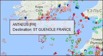
If you zoom in, you will see specific vessels. The map receives updates every few seconds. When you hover over the ship, you can see its name, on the site you can get other information you are interested in searching for.
To find the ship you are interested in, you should enter the name of the ship and, if possible, its localization in the search bar and press the search key. The AIS map will show the position of the vessel in real time.
This map informs not only about the ships, but also about the cargo carried on them, which can be useful for ship charterers. Be with us and not one ship will be lost.
Marine Traffic is a resource with which you can track the position of ships on the AIS (Automatic Identification System) map. This is done very simply: in the search box you need to enter the name of the vessel, and the service will show where it is at the moment. In addition to the name and type of the ship, you can find out its course, the country to which it belongs, the speed of movement and other useful data.
The service is convenient to use - ships of different types are highlighted in different colors, the direction of their movement is shown, those who are at anchor are separately indicated.
Video: MarineTraffic - the world's most popular online ship tracking service
When you hover over the icon, information about the ship appears in a pop-up window: name, home country, destination. If you click on it, the system will show more detailed information right down to the photo.
How does Marinetraffic work?
To create a map of vessels, AIS technology is used - automatic identification system. Each ship has a transmitter that constantly transmits information over the air using radio waves. It does not use mobile and satellite communications, so this technology is cheaper than analogues. Any receiver operating on VHF or VHF frequencies can pick up the signal.
Broadcast coverage depends on several factors. The most significant are the transmitter power and the height of the receiving antenna. But even the weakest repeater can broadcast within 75 km. This is enough for ships to recognize each other's presence from a safe distance.
Marine Traffic - what is it?
Marine traffic is a shareware service to track the location of a vessel online. On the world map you can find any ships that are in port or sailing. In the service options, you can also track the location of the vessel by its name in real time.
When you select a vessel on the map, a window pops up with information about the vessel online:
- vessel name
- vessel type (container, tanker, passenger ship, etc.)
- ship status
- vessel speed
- ship's course
- ship's draft
How Marine traffic and AIS systems work
At the present time, almost all ships are equipped with an automatic identification system AIS, which allows you to track the ship and avoid ship collisions. At what maximum distance can a ship be tracked on a map? It all depends on the height of the antenna located on the ship itself and at the nearest station on land. Regular AIS stations cover a range of about 40 nautical miles (about 75 km). In some cases, the location of the ship can be tracked at a distance of 200 miles, and this is no less than 370 km. But this is the case if the AIS station is located high above sea level, for example, on a mountain, and the ship itself is equipped with a good antenna. Thus, anyone can track the ship online using the Marinetraffic service.
How to track the ship on the map?
If you have the ship's name, the easiest way to find out the ship's location is to enter it in the map search and the system will immediately show the ship's position and information about it. If you know that the ship has not yet left any port or it could not go far from it, you can try to find the desired port in the same search form. And then all the familiar actions of the mouse point at all the ships and see information about them. Also, to make your search easier, you can filter ships by type. For example, select only passenger, fishing or cargo ships. The service is intuitive and if you have the skills to use the map, then it will not be difficult for you to find out the location of the vessel in real time.
Would you like to know where this or that sea vessel is now, which ships are located next to you, and which are moored in Buenos Aires, Sumatra or Singapore? The MarineTraffic.com network service gives you a unique opportunity to get a lot of useful information according to the location and movement of the ship you need on the map, its route, speed, cargo, weather in this region, and so on. In this article, I will talk about the real-time vessel traffic map on the Marina Traffic website, and also explain in detail how to use the capabilities of this service.
AIS navigation
As you know, AIS (automated identification system) has been involved in navigation since the early 90s, the main purpose of which is to increase the monitoring and safety of maritime transport. Its capabilities allow you to identify the vessel, its course, dimensions and other parameters using VHF radio waves. The system covers an area of about 9 million square kilometers of coastal zones around the globe, including about 2,500 ports in the areas of the most active maritime traffic.
In 2004, the International Maritime Organization (IMO) required ships with a gross tonnage of more than 300 tons to be required to install a special AIS transmitter on board the ship. The duties of the latter include transmitting in real time to a special receiving station all the necessary information about the vessel, including its speed, course, position, name, dimensions, and other relevant data.

The MarineTraffic.com site I'm reviewing receives data from over 1200 AIS receiving stations around the world. After collecting the data, they are transferred to the processing center, where they are processed, and applied to the map placed on the service. At the same time, the indicated ship movement map is available online both through the browser of a stationary PC and through the corresponding application for mobile devices.
So what is Marina Traffic?
MarineTraffic is a world-famous network service for tracking the location of ships. The resource collects real-time data about the location of the vessel (as well as information about its course, speed, tonnage, and so on). And displays it on the corresponding map, thereby greatly facilitating the work of people directly related to the sea.

The purpose of the vessel traffic map service is to increase the transparency and efficiency of maritime transport. The site allows you to track the location of many ships, making data on them available to ordinary users. At the same time, the resource is actively developing, inviting interested parties to take a direct part in its formation and further progress.
If you want to look at you need to check out my selection of the best services at the link.
How to use the Marine Traffic real-time ship chart
After going to the marinetraffic.com website, you will immediately be taken to work card service.

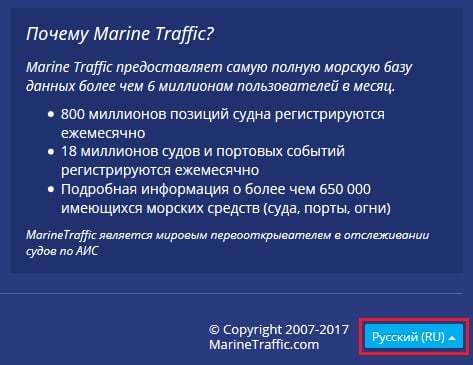
I recommend scrolling down the working screen and using the Russian interface instead of the default English. At the same time, I will warn the reader that most of the interface will remain in English one way or another.
You will then need to go through the registration process (after which a number of special options of the My Fleets level will become available to you, allowing you to track the vessels of your choice). To do this, click on "Login" at the top, then on "Register", and go through the registration procedure via e-mail.
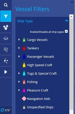
The map shows various types of vessels schematically in different colors (transport, tankers, passenger, high-speed, special, fishing, etc.)
By hovering over the ship you need, you can get information about its name and destination. More detailed information is available only after paying the appropriate fee for using the site (annual subscription, subscription depending on the number of ships you have chosen, and so on).
Service control panel in Russian
The Marina Traffic control panel is divided into two main parts - the left panel and the top panel.
The left panel contains the following options:

The top panel has the following options:
Conclusion
With all the richness of the capabilities of the Marina Traffic website, its free functionality is rather limited, being of interest only in terms of getting acquainted with the capabilities of the service. All the completeness of information on the ship traffic map that the user needs can only be obtained by paying for the paid functionality of the site, which is really quite impressive and will be fully useful to people associated with the sea and shipping.
-
 April 17, 2015The most expensive banknotes of modern Russia
 -
 April 17, 2015What is KBK in details and where to get it?
 -
 April 17, 2015Budget classification code: how to find out?


